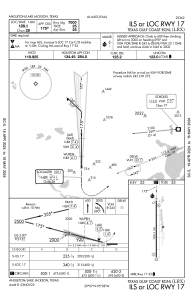
IAC chart of KLBX
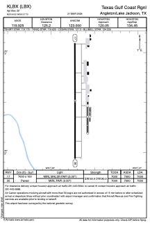
 ADC chart of KLBX
 Satellite view of KLBX
ADC chart of KLBX
Satellite view of KLBX
Sorry, we have no imagery here.
Sorry, we have no imagery here.
Sorry, we have no imagery here.
Sorry, we have no imagery here.
Sorry, we have no imagery here.
Sorry, we have no imagery here.


KLBX - Texas Gulf Coast Rgnl
Located in Angleton/Lake Jackson, United States
ICAO - LBX, IATA - LJN
Data provided by AirmateGeneral information
Coordinates: N29°6'31" W95°27'43"
Elevation is 25 feet MSL.
Magnetic variation is 05° East View others Airports in Texas
Operational data
Special qualification required
Current time UTC:
Current local time:
Weather
TAF: KLBX 020520Z 0206/0306 17014G24KT P6SM BKN017 FM021700 18017G30KT P6SM BKN015 FM030300 16013G22KT P6SM BKN010 AMD NOT SKED
Communications frequencies: [VIEW]
Runways:
| RWY identifier | QFU | Length (ft) | Width (ft) | Surface | LDA (ft) |
| 17 | 180° | 7000 | 100 | CONC | 7000 |
| 35 | 360° | 7000 | 100 | CONC | 7000 |
Airport contact information
Address: Angleton/Lake Jackson United States
Other aviation service providers
Flight schools

Coastal Planes Aviation, Llc
Coastal Planes Aviation, Llc
coastalplanesaviationllc@gmail.com+1(979)292-6971
Satellite view of KLBX
Sorry, we have no imagery here.
Sorry, we have no imagery here.
Sorry, we have no imagery here.
Sorry, we have no imagery here.
Sorry, we have no imagery here.
Sorry, we have no imagery here.