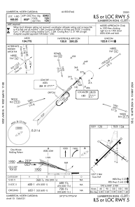
IAC chart of KLBT
 Satellite view of KLBT
Satellite view of KLBT
Sorry, we have no imagery here.
Sorry, we have no imagery here.
Sorry, we have no imagery here.
Sorry, we have no imagery here.
Sorry, we have no imagery here.
Sorry, we have no imagery here.


KLBT - Lumberton Rgnl
Located in Lumberton, United States
ICAO - LBT, IATA - LBT
Data provided by AirmateGeneral information
Coordinates: N34°36'35" W79°3'34"
Elevation is 124 feet MSL.
Magnetic variation is -08° East View others Airports in North Carolina
Operational data
Special qualification required
Current time UTC:
Current local time:
Weather
TAF: KLBT 021138Z 0212/0312 07005KT P6SM OVC025 FM021700 15010G18KT P6SM BKN035 FM030100 15008KT P6SM BKN025 FM030400 17008KT P6SM BKN007
Communications frequencies: [VIEW]
Runways:
| RWY identifier | QFU | Length (ft) | Width (ft) | Surface | LDA (ft) |
| 05 | 45° | 5502 | 150 | ASPH | |
| 23 | 225° | 5502 | 150 | ASPH | |
| 13 | 125° | 5003 | 75 | ASPH | |
| 31 | 305° | 5003 | 75 | ASPH |
Airport contact information
Address: Lumberton United States
Satellite view of KLBT
Sorry, we have no imagery here.
Sorry, we have no imagery here.
Sorry, we have no imagery here.
Sorry, we have no imagery here.
Sorry, we have no imagery here.
Sorry, we have no imagery here.