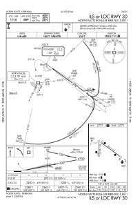
IAC chart of KLBF
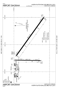
 ADC chart of KLBF
 Satellite view of KLBF
ADC chart of KLBF
Satellite view of KLBF
Sorry, we have no imagery here.
Sorry, we have no imagery here.
Sorry, we have no imagery here.
Sorry, we have no imagery here.
Sorry, we have no imagery here.
Sorry, we have no imagery here.


KLBF - North Platte Rgnl/Lee Bird Fld
Located in North Platte, United States
ICAO - LBF, IATA - LBF
Data provided by AirmateGeneral information
Coordinates: N41°7'34" W100°41'1"
Elevation is 2777 feet MSL.
Magnetic variation is 06° East View others Airports in Nebraska
Operational data
Special qualification required
Current time UTC:
Current local time:
Weather
METAR: KLBF 050853Z AUTO 30007KT 10SM CLR M06/M07 A3040 RMK AO2 SLP320 T10561072 58003
TAF: KLBF 050520Z 0506/0606 33005KT P6SM FEW250 FM051600 36010G20KT P6SM SKC FM060100 02007KT P6SM SKC
Communications frequencies: [VIEW]
Runways:
| RWY identifier | QFU | Length (ft) | Width (ft) | Surface | LDA (ft) |
| 12 | 126° | 8001 | 150 | CONC | 8001 |
| 30 | 306° | 8001 | 150 | CONC | 8001 |
| 17 | 181° | 4436 | 100 | CONC | 4135 |
| 35 | 1° | 4436 | 100 | CONC | 4135 |
Airport contact information
Address: North Platte United States
Satellite view of KLBF
Sorry, we have no imagery here.
Sorry, we have no imagery here.
Sorry, we have no imagery here.
Sorry, we have no imagery here.
Sorry, we have no imagery here.
Sorry, we have no imagery here.