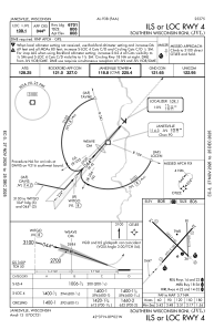
IAC chart of KJVL
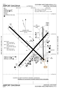
 ADC chart of KJVL
 Satellite view of KJVL
ADC chart of KJVL
Satellite view of KJVL
Sorry, we have no imagery here.
Sorry, we have no imagery here.
Sorry, we have no imagery here.
Sorry, we have no imagery here.
Sorry, we have no imagery here.
Sorry, we have no imagery here.


KJVL - Southern Wisconsin Rgnl
Located in Janesville, United States
ICAO - JVL, IATA - JVL
Data provided by AirmateGeneral information
Coordinates: N42°37'13" W89°2'30"
Elevation is 807 feet MSL.
Magnetic variation is -02° East View others Airports in Wisconsin
Operational data
Special qualification required
Current time UTC:
Current local time:
Weather
METAR: KJVL 281545Z 01007KT 10SM OVC070 13/11 A3010
TAF: KJVL 281510Z 2815/2912 02006KT P6SM SCT070 OVC100 FM282100 02008KT P6SM OVC025 FM290400 36004KT P6SM BKN015
Communications frequencies: [VIEW]
Runways:
| RWY identifier | QFU | Length (ft) | Width (ft) | Surface | LDA (ft) |
| 04 | 42° | 6701 | 150 | ASPH | 6701 |
| 22 | 222° | 6701 | 150 | ASPH | 6701 |
| 14 | 134° | 7302 | 150 | CONC | 7302 |
| 32 | 314° | 7302 | 150 | CONC | 7302 |
| 18 | 179° | 5004 | 75 | ASPH | 5004 |
| 36 | 359° | 5004 | 75 | ASPH | 5004 |
Airport contact information
Address: Janesville United States
Other aviation service providers
Flight schools

Satellite view of KJVL
Sorry, we have no imagery here.
Sorry, we have no imagery here.
Sorry, we have no imagery here.
Sorry, we have no imagery here.
Sorry, we have no imagery here.
Sorry, we have no imagery here.