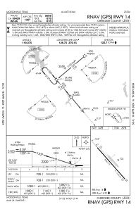
IAC chart of KJSO
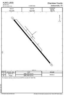
 ADC chart of KJSO
 Satellite view of KJSO
ADC chart of KJSO
Satellite view of KJSO
Sorry, we have no imagery here.
Sorry, we have no imagery here.
Sorry, we have no imagery here.
Sorry, we have no imagery here.
Sorry, we have no imagery here.
Sorry, we have no imagery here.


KJSO - Cherokee County
Located in Jacksonville, United States
ICAO - JSO, IATA - JKV
Data provided by AirmateGeneral information
Coordinates: N31°52'10" W95°13'3"
Elevation is 677 feet MSL.
Magnetic variation is 05° East View others Airports in Texas
Operational data
Special qualification required
Current time UTC:
Current local time:
Weather
METAR: KJSO 020115Z AUTO 16015G22KT 8SM OVC008 23/22 A2959 RMK AO2 CIG 007V011 T02260221
Communications frequencies: [VIEW]
Runways:
| RWY identifier | QFU | Length (ft) | Width (ft) | Surface | LDA (ft) |
| 14 | 140° | 5006 | 75 | ASPH | |
| 32 | 320° | 5006 | 75 | ASPH |
Airport contact information
Address: Jacksonville United States
Other aviation service providers
Flight schools

Satellite view of KJSO
Sorry, we have no imagery here.
Sorry, we have no imagery here.
Sorry, we have no imagery here.
Sorry, we have no imagery here.
Sorry, we have no imagery here.
Sorry, we have no imagery here.