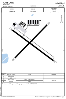
ADC chart of KJOT
 Satellite view of KJOT
Satellite view of KJOT
Sorry, we have no imagery here.
Sorry, we have no imagery here.
Sorry, we have no imagery here.
Sorry, we have no imagery here.
Sorry, we have no imagery here.


KJOT - Joliet Rgnl
Located in Joliet, United States
ICAO - JOT, IATA - JOT
Data provided by AirmateGeneral information
Coordinates: N41°31'4" W88°10'31"
Elevation is 582 feet MSL.
Magnetic variation is -03° East View others Airports in Illinois
Operational data
Special qualification required
Current time UTC:
Current local time:
Weather
METAR: KJOT 081215Z AUTO 35005KT 10SM CLR M02/M07 A3021 RMK AO2 T10201073
Communications frequencies: [VIEW]
Runways:
| RWY identifier | QFU | Length (ft) | Width (ft) | Surface | LDA (ft) |
| 04 | 44° | 2552 | 150 | GRASS | |
| 22 | 224° | 2552 | 150 | GRASS | |
| 13 | 127° | 2821 | 100 | ASPH | |
| 31 | 307° | 2821 | 100 | ASPH |
Airport contact information
Address: Joliet United States
Other aviation service providers
Flight schools

Satellite view of KJOT
Sorry, we have no imagery here.
Sorry, we have no imagery here.
Sorry, we have no imagery here.
Sorry, we have no imagery here.
Sorry, we have no imagery here.