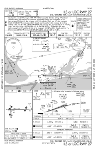
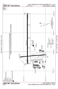
KJKA - Gulf Shores Intl/Jack Edwards Fld
Located in Gulf Shores, United States
ICAO - JKA, IATA - GUF
Data provided by AirmateGeneral information
Coordinates: N30°17'23" W87°40'18"
Elevation is 17 feet MSL.
Magnetic variation is 00° East View others Airports in Alabama
Operational data
Special qualification required
Current time UTC:
Current local time:
Weather
METAR: KJKA 042255Z 11010KT 4SM BR OVC007 24/22 A3012
TAF: KJKA 041809Z 0418/0518 12013G20KT P6SM SCT012 FM050300 13011KT P6SM OVC004 FM051500 15015G20KT P6SM OVC008
Communications frequencies: [VIEW]
Runways:
| RWY identifier | QFU | Length (ft) | Width (ft) | Surface | LDA (ft) |
| 09 | 90° | 6962 | 100 | ASPH | 6500 |
| 27 | 270° | 6962 | 100 | ASPH | 6500 |
| 17 | 175° | 3596 | 75 | ASPH | 3276 |
| 35 | 355° | 3596 | 75 | ASPH | 3276 |
Airport contact information
Address: Gulf Shores United States
Other aviation service providers
Repair station
Resicum International Dba Aeropro
Resicum International Dba Aeropro
phillip@aeroproinflight.com215-200-8521
Flight schools
Satellite view of KJKA
Sorry, we have no imagery here.
Sorry, we have no imagery here.
Sorry, we have no imagery here.
Sorry, we have no imagery here.
Sorry, we have no imagery here.
Sorry, we have no imagery here.


