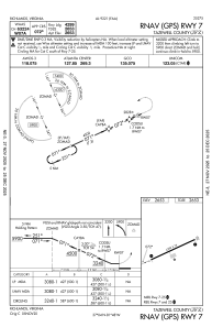
IAC chart of KJFZ
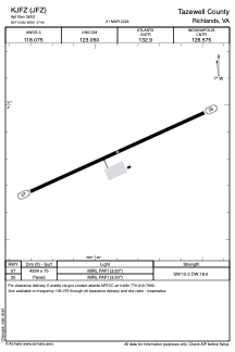
 ADC chart of KJFZ
 Satellite view of KJFZ
ADC chart of KJFZ
Satellite view of KJFZ
Sorry, we have no imagery here.
Sorry, we have no imagery here.
Sorry, we have no imagery here.
Sorry, we have no imagery here.
Sorry, we have no imagery here.
Sorry, we have no imagery here.


KJFZ - Tazewell County
Located in Richlands, United States
ICAO - JFZ, IATA -
Data provided by AirmateGeneral information
Coordinates: N37°3'49" W81°47'54"
Elevation is 2653 feet MSL.
Magnetic variation is -06° East View others Airports in Virginia
Operational data
Special qualification required
Current time UTC:
Current local time:
Weather
METAR: KJFZ 010555Z AUTO 31006KT 10SM OVC005 04/04 A2994 RMK AO2 60001 T00400035 10102 20040 401800040
Communications frequencies: [VIEW]
Runways:
| RWY identifier | QFU | Length (ft) | Width (ft) | Surface | LDA (ft) |
| 07 | 66° | 4299 | 75 | ASPH | |
| 25 | 246° | 4299 | 75 | ASPH |
Airport contact information
Address: Richlands United States
Satellite view of KJFZ
Sorry, we have no imagery here.
Sorry, we have no imagery here.
Sorry, we have no imagery here.
Sorry, we have no imagery here.
Sorry, we have no imagery here.
Sorry, we have no imagery here.