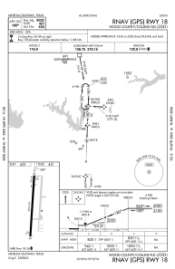
IAC chart of KJDD
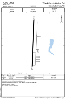
 ADC chart of KJDD
 Satellite view of KJDD
ADC chart of KJDD
Satellite view of KJDD
Sorry, we have no imagery here.
Sorry, we have no imagery here.
Sorry, we have no imagery here.
Sorry, we have no imagery here.
Sorry, we have no imagery here.
Sorry, we have no imagery here.


KJDD - Wood County/Collins Fld
Located in Mineola/Quitman, United States
ICAO - JDD, IATA -
Data provided by AirmateGeneral information
Coordinates: N32°44'32" W95°29'47"
Elevation is 432 feet MSL.
Magnetic variation is 02° East View others Airports in Texas
Operational data
Special qualification required
Current time UTC:
Current local time:
Weather
METAR: KJDD 020615Z AUTO 18011G15KT 140V200 10SM BKN029 OVC035 23/19 A2959 RMK AO2 CIG 024V032 T02290190 $
Communications frequencies: [VIEW]
Runways:
| RWY identifier | QFU | Length (ft) | Width (ft) | Surface | LDA (ft) |
| 18 | 182° | 4002 | 60 | ASPH | |
| 36 | 2° | 4002 | 60 | ASPH |
Airport contact information
Address: Mineola/Quitman United States
Other aviation service providers
Flight schools

Satellite view of KJDD
Sorry, we have no imagery here.
Sorry, we have no imagery here.
Sorry, we have no imagery here.
Sorry, we have no imagery here.
Sorry, we have no imagery here.
Sorry, we have no imagery here.