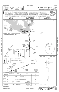
IAC chart of KJAS
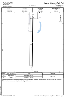
 ADC chart of KJAS
 Satellite view of KJAS
ADC chart of KJAS
Satellite view of KJAS
Sorry, we have no imagery here.
Sorry, we have no imagery here.
Sorry, we have no imagery here.
Sorry, we have no imagery here.
Sorry, we have no imagery here.
Sorry, we have no imagery here.


KJAS - Jasper County/Bell Fld
Located in Jasper, United States
ICAO - JAS, IATA - JAS
Data provided by AirmateGeneral information
Coordinates: N30°53'8" W94°2'6"
Elevation is 212 feet MSL.
Magnetic variation is 04° East View others Airports in Texas
Operational data
Special qualification required
Current time UTC:
Current local time:
Weather
METAR: KJAS 012315Z AUTO 14005KT 5SM BR SCT014 BKN019 OVC035 24/24 A2971 RMK AO2
Communications frequencies: [VIEW]
Runways:
| RWY identifier | QFU | Length (ft) | Width (ft) | Surface | LDA (ft) |
| 18 | 181° | 5500 | 70 | ASPH | |
| 36 | 1° | 5500 | 70 | ASPH |
Airport contact information
Address: Jasper United States
Satellite view of KJAS
Sorry, we have no imagery here.
Sorry, we have no imagery here.
Sorry, we have no imagery here.
Sorry, we have no imagery here.
Sorry, we have no imagery here.
Sorry, we have no imagery here.