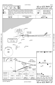
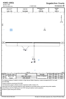
KIWD - Gogebic/Iron County
Located in Ironwood, United States
ICAO - IWD, IATA - IWD
Data provided by AirmateGeneral information
Coordinates: N46°31'39" W90°7'53"
Elevation is 1230 feet MSL.
Magnetic variation is 00° East View others Airports in Michigan
Operational data
Special qualification required
Current time UTC:
Current local time:
Weather
METAR: KIWD 030313Z AUTO 21006KT 10SM BKN009 OVC013 03/02 A2927 RMK AO2 CIG 007V011
TAF: KIWD 022320Z 0300/0324 11008KT 6SM -RA BR BKN007 WS020/19040KT FM030400 21008KT 6SM BR BKN005 PROB30 0306/0309 2SM -RASN FM030900 26014G25KT 4SM BR OVC006 PROB30 0309/0312 2SM -SN FM031200 27016G25KT P6SM BKN011 FM032100 28011KT P6SM BKN025
Communications frequencies: [VIEW]
Runways:
| RWY identifier | QFU | Length (ft) | Width (ft) | Surface | LDA (ft) |
| 09 | 90° | 6502 | 100 | ASPH | 6501 |
| 27 | 270° | 6502 | 100 | ASPH | 6501 |
Airport contact information
Address: Ironwood United States
Satellite view of KIWD
Sorry, we have no imagery here.
Sorry, we have no imagery here.
Sorry, we have no imagery here.
Sorry, we have no imagery here.
Sorry, we have no imagery here.
Sorry, we have no imagery here.


