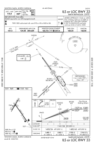
IAC chart of KINT
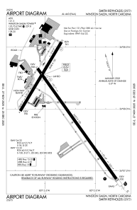
 ADC chart of KINT
 Satellite view of KINT
ADC chart of KINT
Satellite view of KINT
Sorry, we have no imagery here.
Sorry, we have no imagery here.
Sorry, we have no imagery here.
Sorry, we have no imagery here.
Sorry, we have no imagery here.


KINT - Smith Reynolds
Located in Winston Salem, United States
ICAO - INT, IATA - INT
Data provided by AirmateGeneral information
Coordinates: N36°8'1" W80°13'19"
Elevation is 969 feet MSL.
Magnetic variation is -07° East View others Airports in North Carolina
Operational data
Special qualification required
Current time UTC:
Current local time:
Weather
METAR: KINT 020254Z AUTO 10003KT 10SM CLR 13/03 A3016 RMK AO2 SLP208 T01330033 51023
TAF: KINT 012334Z 0200/0224 08004KT P6SM SCT250 FM020800 08005KT P6SM BKN007 FM021200 09005KT P6SM OVC007 FM021800 10006KT P6SM BKN007
Communications frequencies: [VIEW]
Runways:
| RWY identifier | QFU | Length (ft) | Width (ft) | Surface | LDA (ft) |
| 04 | 31° | 3938 | 150 | ASPH | 3938 |
| 22 | 211° | 3938 | 150 | ASPH | 3938 |
| 15 | 145° | 6655 | 150 | ASPH | 6069 |
| 33 | 325° | 6655 | 150 | ASPH | 6655 |
Airport contact information
Address: Winston Salem United States
Other aviation service providers
Flight schools

Satellite view of KINT
Sorry, we have no imagery here.
Sorry, we have no imagery here.
Sorry, we have no imagery here.
Sorry, we have no imagery here.
Sorry, we have no imagery here.