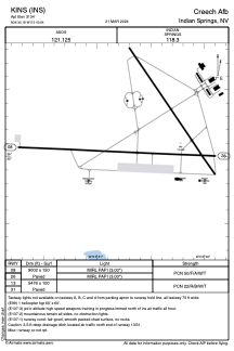
KINS - Creech Afb
Located in Indian Springs, United States
ICAO - INS, IATA - INS
Data provided by AirmateGeneral information
Coordinates: N36°35'11" W115°40'39"
Elevation is 3134 feet MSL.
Magnetic variation is 15° East View others Airports in Nevada
Operational data
Special qualification required
Current time UTC:
Current local time:
Weather
METAR: KINS 041955Z AUTO 05007KT 10SM FEW085 16/M09 A3009 RMK AO2 SLP172 T01561094 $
TAF: TAF KINS 041257Z 0413/0519 VRB06KT 9999 FEW110 QNH3000INS BECMG 0415/0416 03009KT 9999 FEW100 QNH3003INS BECMG 0418/0419 03012G18KT 9999 BKN090 610902 QNH2998INS BECMG 0420/0421 03015G22KT 9999 VCSH SCT060 BKN080 610803 510009 QNH2999INS TEMPO 0421/0501 06018G25KT 9000 -SHRA 520009 BECMG 0502/0503 06014KT 9999 NSW BKN100 611002 QNH3000INS BECMG 0504/0505 21012KT 9999 BKN120 QNH3005INS BECMG 0515/0516 03012KT 9999 SKC QNH3026INS TX17/0423Z TN03/0413Z
Communications frequencies: [VIEW]
Runways:
| RWY identifier | QFU | Length (ft) | Width (ft) | Surface | LDA (ft) |
| 08 | 93° | 9002 | 150 | ASPH | |
| 26 | 273° | 9002 | 150 | ASPH | |
| 13 | 0° | 5476 | 100 | ASPH | |
| 31 | 0° | 5476 | 100 | ASPH |
Airport contact information
Address: Indian Springs United States
Satellite view of KINS
Sorry, we have no imagery here.
Sorry, we have no imagery here.
Sorry, we have no imagery here.
Sorry, we have no imagery here.
Sorry, we have no imagery here.
Sorry, we have no imagery here.


