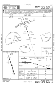
IAC chart of KINJ
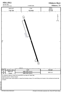
 ADC chart of KINJ
 Satellite view of KINJ
ADC chart of KINJ
Satellite view of KINJ
Sorry, we have no imagery here.
Sorry, we have no imagery here.
Sorry, we have no imagery here.
Sorry, we have no imagery here.
Sorry, we have no imagery here.


KINJ - Hillsboro Muni
Located in Hillsboro, United States
ICAO - INJ, IATA -
Data provided by AirmateGeneral information
Coordinates: N32°5'1" W97°5'50"
Elevation is 685 feet MSL.
Magnetic variation is 06° East View others Airports in Texas
Operational data
Special qualification required
Current time UTC:
Current local time:
Weather
METAR: KINJ 021415Z AUTO 22009KT 1 1/2SM +RA BKN012 OVC018 22/22 A2960 RMK AO2 T02240224
Communications frequencies: [VIEW]
Runways:
| RWY identifier | QFU | Length (ft) | Width (ft) | Surface | LDA (ft) |
| 16 | 162° | 3998 | 60 | ASPH | |
| 34 | 342° | 3998 | 60 | ASPH |
Airport contact information
Address: Hillsboro United States
Satellite view of KINJ
Sorry, we have no imagery here.
Sorry, we have no imagery here.
Sorry, we have no imagery here.
Sorry, we have no imagery here.
Sorry, we have no imagery here.