IAC chart of KIDI
 ADC chart of KIDI
 Satellite view of KIDI
ADC chart of KIDI
Satellite view of KIDI
Sorry, we have no imagery here.
Sorry, we have no imagery here.
Sorry, we have no imagery here.
Sorry, we have no imagery here.
Sorry, we have no imagery here.
Sorry, we have no imagery here.


KIDI - Indiana County/Jimmy Stewart Fld
Located in Indiana, United States
ICAO - IDI, IATA - IDI
Data provided by AirmateGeneral information
Coordinates: N40°37'52" W79°6'5"
Elevation is 1419 feet MSL.
Magnetic variation is -10° East View others Airports in Pennsylvania
Operational data
Special qualification required
Current time UTC:
Current local time:
Weather
METAR: KIDI 081415Z AUTO 29021G31KT 10SM SCT036 BKN042 OVC048 M01/M09 A2993 RMK A01
Communications frequencies: [VIEW]
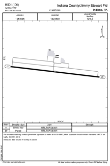
Runways:
| RWY identifier | QFU | Length (ft) | Width (ft) | Surface | LDA (ft) |
| 11 | 96° | 5502 | 100 | ASPH | |
| 29 | 276° | 5502 | 100 | ASPH |
Airport contact information
Address: Indiana United States
Other aviation service providers
Flight schools

Satellite view of KIDI
Sorry, we have no imagery here.
Sorry, we have no imagery here.
Sorry, we have no imagery here.
Sorry, we have no imagery here.
Sorry, we have no imagery here.
Sorry, we have no imagery here.