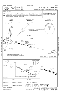
IAC chart of KIBM
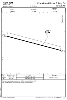
 ADC chart of KIBM
 Satellite view of KIBM
ADC chart of KIBM
Satellite view of KIBM
Sorry, we have no imagery here.
Sorry, we have no imagery here.
Sorry, we have no imagery here.
Sorry, we have no imagery here.
Sorry, we have no imagery here.
Sorry, we have no imagery here.


KIBM - Kimball Muni/Robert E Arraj Fld
Located in Kimball, United States
ICAO - IBM, IATA -
Data provided by AirmateGeneral information
Coordinates: N41°11'17" W103°40'39"
Elevation is 4925 feet MSL.
Magnetic variation is 10° East View others Airports in Nebraska
Operational data
Special qualification required
Current time UTC:
Current local time:
Weather
METAR: KIBM 070535Z AUTO 30008KT 10SM CLR 01/M05 A3010 RMK AO2 T00051048
Communications frequencies: [VIEW]
Runways:
| RWY identifier | QFU | Length (ft) | Width (ft) | Surface | LDA (ft) |
| 10 | 105° | 6199 | 75 | CONC | |
| 28 | 285° | 6199 | 75 | CONC |
Airport contact information
Address: Kimball United States
Satellite view of KIBM
Sorry, we have no imagery here.
Sorry, we have no imagery here.
Sorry, we have no imagery here.
Sorry, we have no imagery here.
Sorry, we have no imagery here.
Sorry, we have no imagery here.