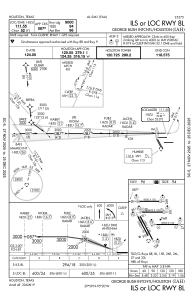
IAC chart of KIAH
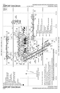
 ADC chart of KIAH
 Satellite view of KIAH
ADC chart of KIAH
Satellite view of KIAH
Sorry, we have no imagery here.
Sorry, we have no imagery here.
Sorry, we have no imagery here.
Sorry, we have no imagery here.
Sorry, we have no imagery here.
Sorry, we have no imagery here.


KIAH - George Bush Intcntl/Houston
Located in Houston, United States
ICAO - IAH, IATA - IAH
Data provided by AirmateGeneral information
Coordinates: N29°59'4" W95°20'29"
Elevation is 95 feet MSL.
Magnetic variation is 03° East View others Airports in Texas
Operational data
Special qualification required
Current time UTC:
Current local time:
Weather
METAR: KIAH 012253Z 16014G23KT 10SM SCT041 SCT250 28/20 A2967 RMK AO2 SLP045 T02830200
TAF: KIAH 012320Z 0200/0306 16014G24KT P6SM SCT025 BKN050 BKN250 FM020600 16018G25KT 6SM BR BKN015 FM021400 18016G24KT P6SM OVC015 FM021700 17017G28KT P6SM SCT015 OVC025 FM030100 17015KT P6SM OVC015
Communications frequencies: [VIEW]
Runways:
| RWY identifier | QFU | Length (ft) | Width (ft) | Surface | LDA (ft) |
| 08L | 90° | 9000 | 150 | CONC | 9000 |
| 26R | 270° | 9000 | 150 | CONC | 9000 |
| 08R | 90° | 9402 | 150 | CONC | 9402 |
| 26L | 270° | 9402 | 150 | CONC | 9402 |
| 09 | 90° | 10000 | 150 | CONC | 10000 |
| 27 | 270° | 10000 | 150 | CONC | 10000 |
| 15L | 152° | 12001 | 150 | CONC | 12001 |
| 33R | 332° | 12001 | 150 | CONC | 12001 |
| 15R | 152° | 10000 | 150 | CONC | 10000 |
| 33L | 332° | 10000 | 150 | CONC | 10000 |
Airport contact information
Address: Houston United States
Satellite view of KIAH
Sorry, we have no imagery here.
Sorry, we have no imagery here.
Sorry, we have no imagery here.
Sorry, we have no imagery here.
Sorry, we have no imagery here.
Sorry, we have no imagery here.