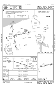
IAC chart of KHZY
 Satellite view of KHZY
Satellite view of KHZY
Sorry, we have no imagery here.
Sorry, we have no imagery here.
Sorry, we have no imagery here.
Sorry, we have no imagery here.
Sorry, we have no imagery here.
Sorry, we have no imagery here.


KHZY - Northeast Ohio Rgnl
Located in Ashtabula, United States
ICAO - HZY, IATA - JFN
Data provided by AirmateGeneral information
Coordinates: N41°46'40" W80°41'48"
Elevation is 926 feet MSL.
Magnetic variation is -09° East View others Airports in Ohio
Operational data
Special qualification required
Current time UTC:
Current local time:
Weather
METAR: KHZY 081653Z AUTO 30012G21KT 10SM SCT029 OVC043 M02/M09 A3005 RMK AO2 SNB1556E21 SLP185 P0000 T10171089 $
Communications frequencies: [VIEW]
Runways:
| RWY identifier | QFU | Length (ft) | Width (ft) | Surface | LDA (ft) |
| 09 | 79° | 5900 | 100 | ASPH | 5100 |
| 27 | 259° | 5900 | 100 | ASPH | 5100 |
Airport contact information
Address: Ashtabula United States
Satellite view of KHZY
Sorry, we have no imagery here.
Sorry, we have no imagery here.
Sorry, we have no imagery here.
Sorry, we have no imagery here.
Sorry, we have no imagery here.
Sorry, we have no imagery here.