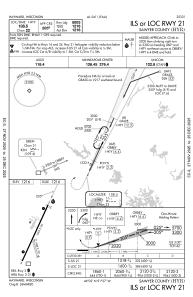
IAC chart of KHYR
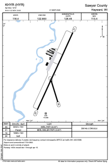
 ADC chart of KHYR
 Satellite view of KHYR
ADC chart of KHYR
Satellite view of KHYR
Sorry, we have no imagery here.
Sorry, we have no imagery here.
Sorry, we have no imagery here.
Sorry, we have no imagery here.
Sorry, we have no imagery here.
Sorry, we have no imagery here.


KHYR - Sawyer County
Located in Hayward, United States
ICAO - HYR, IATA - HYR
Data provided by AirmateGeneral information
Coordinates: N46°1'31" W91°26'39"
Elevation is 1216 feet MSL.
Magnetic variation is 00° East View others Airports in Wisconsin
Operational data
Special qualification required
Current time UTC:
Current local time:
Weather
METAR: KHYR 300253Z AUTO 22004KT 10SM BKN110 18/10 A2994 RMK AO2 SLP138 T01830100 55004
TAF: KHYR 292320Z 3000/3024 20005KT P6SM BKN120 FM301700 32010G19KT P6SM SCT250
Communications frequencies: [VIEW]
Runways:
| RWY identifier | QFU | Length (ft) | Width (ft) | Surface | LDA (ft) |
| 03 | 25° | 5002 | 100 | ASPH | |
| 21 | 205° | 5002 | 100 | ASPH | |
| 16 | 163° | 1088 | 120 | GRASS | |
| 34 | 343° | 1088 | 120 | GRASS |
Airport contact information
Address: Hayward United States
Other aviation service providers
Flight schools

Satellite view of KHYR
Sorry, we have no imagery here.
Sorry, we have no imagery here.
Sorry, we have no imagery here.
Sorry, we have no imagery here.
Sorry, we have no imagery here.
Sorry, we have no imagery here.