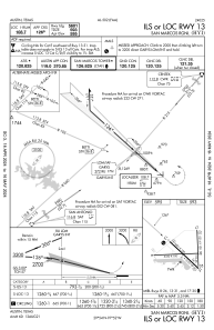
IAC chart of KHYI
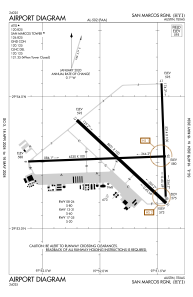
 ADC chart of KHYI
 Satellite view of KHYI
ADC chart of KHYI
Satellite view of KHYI
Sorry, we have no imagery here.
Sorry, we have no imagery here.
Sorry, we have no imagery here.
Sorry, we have no imagery here.
Sorry, we have no imagery here.
Sorry, we have no imagery here.


KHYI - San Marcos Rgnl
Located in Austin, United States
ICAO - HYI, IATA -
Data provided by AirmateGeneral information
Coordinates: N29°53'34" W97°51'47"
Elevation is 594 feet MSL.
Magnetic variation is 07° East View others Airports in Texas
Operational data
Special qualification required
Current time UTC:
Current local time:
Weather
METAR: KHYI 021356Z 16012KT 8SM OVC020 23/23 A2958 RMK AO2 SLP010 T02330228
Communications frequencies: [VIEW]
Runways:
| RWY identifier | QFU | Length (ft) | Width (ft) | Surface | LDA (ft) |
| 08 | 88° | 6330 | 100 | ASPH | |
| 26 | 268° | 6330 | 100 | ASPH | |
| 13 | 133° | 5601 | 100 | ASPH | |
| 31 | 313° | 5601 | 100 | ASPH | |
| 17 | 178° | 5214 | 100 | ASPH | |
| 35 | 358° | 5214 | 100 | ASPH |
Airport contact information
Address: Austin United States
Other aviation service providers
Flight schools

Satellite view of KHYI
Sorry, we have no imagery here.
Sorry, we have no imagery here.
Sorry, we have no imagery here.
Sorry, we have no imagery here.
Sorry, we have no imagery here.
Sorry, we have no imagery here.