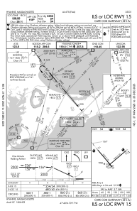
IAC chart of KHYA
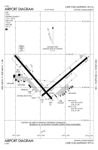
 ADC chart of KHYA
 Satellite view of KHYA
ADC chart of KHYA
Satellite view of KHYA
Sorry, we have no imagery here.
Sorry, we have no imagery here.
Sorry, we have no imagery here.
Sorry, we have no imagery here.
Sorry, we have no imagery here.
Sorry, we have no imagery here.


KHYA - Cape Cod Gateway
Located in Hyannis, United States
ICAO - HYA, IATA - HYA
Data provided by AirmateGeneral information
Coordinates: N41°40'10" W70°16'49"
Elevation is 54 feet MSL.
Magnetic variation is -16° East View others Airports in Massachusetts
Operational data
Special qualification required
Current time UTC:
Current local time:
Weather
METAR: KHYA 011556Z 35015G28KT 10SM CLR 08/02 A2977 RMK AO2 PK WND 36029/1545 SLP081 T00780022
TAF: KHYA 011120Z 0112/0212 33011G21KT P6SM -RA BKN010 OVC050 FM011300 33014G26KT P6SM OVC025 FM011400 33015G26KT P6SM BKN040 FM011700 34013G22KT P6SM SCT250 FM012300 35008KT P6SM FEW250 FM020800 01004KT P6SM SCT250
Communications frequencies: [VIEW]
Runways:
| RWY identifier | QFU | Length (ft) | Width (ft) | Surface | LDA (ft) |
| 06 | 50° | 5425 | 150 | ASPH | 5019 |
| 24 | 230° | 5425 | 150 | ASPH | 5425 |
| 15 | 140° | 5255 | 150 | ASPH | 5255 |
| 33 | 320° | 5255 | 150 | ASPH | 5105 |
Airport contact information
Address: Hyannis United States
Other aviation service providers
Repair station

Satellite view of KHYA
Sorry, we have no imagery here.
Sorry, we have no imagery here.
Sorry, we have no imagery here.
Sorry, we have no imagery here.
Sorry, we have no imagery here.
Sorry, we have no imagery here.