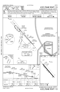
IAC chart of KHWY
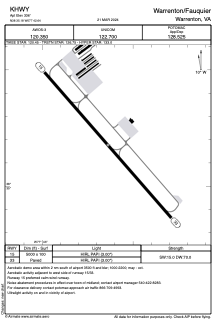
 ADC chart of KHWY
 Satellite view of KHWY
ADC chart of KHWY
Satellite view of KHWY
Sorry, we have no imagery here.
Sorry, we have no imagery here.
Sorry, we have no imagery here.
Sorry, we have no imagery here.
Sorry, we have no imagery here.
Sorry, we have no imagery here.


KHWY - Warrenton/Fauquier
Located in Warrenton, United States
ICAO - HWY, IATA -
Data provided by AirmateGeneral information
Coordinates: N38°35'11" W77°42'38"
Elevation is 336 feet MSL.
Magnetic variation is -10° East View others Airports in Virginia
Operational data
Special qualification required
Current time UTC:
Current local time:
Weather
METAR: KHWY 010715Z AUTO 31011G17KT 10SM SCT060 10/03 A2981 RMK AO2 T01030033
Communications frequencies: [VIEW]
Runways:
| RWY identifier | QFU | Length (ft) | Width (ft) | Surface | LDA (ft) |
| 15 | 139° | 5000 | 100 | ASPH | |
| 33 | 319° | 5000 | 100 | ASPH |
Airport contact information
Address: Warrenton United States
Other aviation service providers
Repair station

Flight schools

Satellite view of KHWY
Sorry, we have no imagery here.
Sorry, we have no imagery here.
Sorry, we have no imagery here.
Sorry, we have no imagery here.
Sorry, we have no imagery here.
Sorry, we have no imagery here.