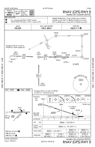
IAC chart of KHVR
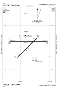
 ADC chart of KHVR
 Satellite view of KHVR
ADC chart of KHVR
Satellite view of KHVR
Sorry, we have no imagery here.
Sorry, we have no imagery here.
Sorry, we have no imagery here.
Sorry, we have no imagery here.
Sorry, we have no imagery here.
Sorry, we have no imagery here.


KHVR - Havre City-County
Located in Havre, United States
ICAO - HVR, IATA - HVR
Data provided by AirmateGeneral information
Coordinates: N48°32'35" W109°45'44"
Elevation is 2591 feet MSL.
Magnetic variation is 13° East View others Airports in Montana
Operational data
Special qualification required
Current time UTC:
Current local time:
Weather
METAR: KHVR 050753Z AUTO 22010KT 10SM CLR M03/M06 A3035 RMK AO2 SLP304 T10331061
TAF: KHVR 050533Z 0506/0606 VRB06KT P6SM SKC FM051100 23010KT P6SM SKC
Communications frequencies: [VIEW]
Runways:
| RWY identifier | QFU | Length (ft) | Width (ft) | Surface | LDA (ft) |
| 03 | 45° | 3699 | 60 | ASPH | 3699 |
| 21 | 225° | 3699 | 60 | ASPH | 3699 |
| 08 | 90° | 5205 | 100 | ASPH | 5205 |
| 26 | 270° | 5205 | 100 | ASPH | 5205 |
Airport contact information
Address: Havre United States
Satellite view of KHVR
Sorry, we have no imagery here.
Sorry, we have no imagery here.
Sorry, we have no imagery here.
Sorry, we have no imagery here.
Sorry, we have no imagery here.
Sorry, we have no imagery here.