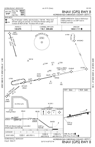
IAC chart of KHVC
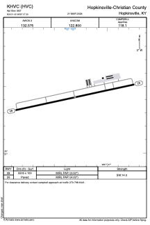
 ADC chart of KHVC
 Satellite view of KHVC
ADC chart of KHVC
Satellite view of KHVC
Sorry, we have no imagery here.
Sorry, we have no imagery here.
Sorry, we have no imagery here.
Sorry, we have no imagery here.
Sorry, we have no imagery here.
Sorry, we have no imagery here.


KHVC - Hopkinsville-Christian County
Located in Hopkinsville, United States
ICAO - HVC, IATA -
Data provided by AirmateGeneral information
Coordinates: N36°51'25" W87°27'18"
Elevation is 563 feet MSL.
Magnetic variation is -01° East View others Airports in Kentucky
Operational data
Special qualification required
Current time UTC:
Current local time:
Weather at : KHOP - Campbell Aaf (Fort Campbell) ( 21 km )
METAR: KHOP 012255Z AUTO 09009KT 10SM CLR 18/05 A2990 RMK AO2 SLP127 T01840052
TAF: TAF KHOP 011600Z 0116/0222 12010G18KT 9999 SCT200 QNH3007INS BECMG 0209/0210 18015G30KT 9999 OVC040 QNH2977INS BECMG 0212/0213 18015G35KT 6000 -TSRA OVC025CB QNH2966INS TEMPO 0216/0222 18020G45KT 2400 +TSRA OVC020CB TX23/0216Z TN10/0116Z
Communications frequencies: [VIEW]
Runways:
| RWY identifier | QFU | Length (ft) | Width (ft) | Surface | LDA (ft) |
| 08 | 78° | 5505 | 100 | ASPH | |
| 26 | 258° | 5505 | 100 | ASPH |
Airport contact information
Address: Hopkinsville United States
Satellite view of KHVC
Sorry, we have no imagery here.
Sorry, we have no imagery here.
Sorry, we have no imagery here.
Sorry, we have no imagery here.
Sorry, we have no imagery here.
Sorry, we have no imagery here.