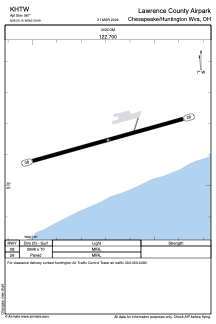
ADC chart of KHTW
 Satellite view of KHTW
Satellite view of KHTW
Sorry, we have no imagery here.
Sorry, we have no imagery here.
Sorry, we have no imagery here.
Sorry, we have no imagery here.
Sorry, we have no imagery here.
Sorry, we have no imagery here.


KHTW - Lawrence County Airpark
Located in Chesapeake/Huntington Wva, United States
ICAO - HTW, IATA -
Data provided by AirmateGeneral information
Coordinates: N38°25'9" W82°29'41"
Elevation is 567 feet MSL.
Magnetic variation is -05° East View others Airports in Ohio
Operational data
Special qualification required
Current time UTC:
Current local time:
Weather at : KHTS - Tri-State/Milton J Ferguson Fld ( 8 km )
METAR: KHTS 071151Z 35007KT 8SM BKN006 OVC011 04/02 A2981 RMK AO2 RAE01B28E50 CIG 005V009 SLP099 P0001 60003 70026 T00390017 10044 20039 58005
TAF: KHTS 071135Z 0712/0812 03005KT 6SM -RA BR OVC006 FM071500 36005KT P6SM OVC010 FM071700 34004KT P6SM OVC015 FM071900 32007KT P6SM OVC050 FM072100 32006KT P6SM SCT100
Communications frequencies: [VIEW]
Runways:
| RWY identifier | QFU | Length (ft) | Width (ft) | Surface | LDA (ft) |
| 08 | 75° | 2998 | 70 | ASPH | |
| 26 | 255° | 2998 | 70 | ASPH |
Airport contact information
Address: Chesapeake/Huntington Wva United States
Satellite view of KHTW
Sorry, we have no imagery here.
Sorry, we have no imagery here.
Sorry, we have no imagery here.
Sorry, we have no imagery here.
Sorry, we have no imagery here.
Sorry, we have no imagery here.