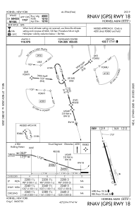
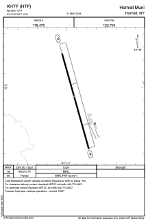


KHTF - Hornell Muni
Located in Hornell, United States
ICAO - HTF, IATA -
Data provided by AirmateGeneral information
Coordinates: N42°22'56" W77°40'56"
Elevation is 1219 feet MSL.
Magnetic variation is -11° East View others Airports in New York
Operational data
Special qualification required
Current time UTC:
Current local time:
Weather at : KDSV - Dansville Muni ( 21 km )
METAR: KDSV 260354Z AUTO 17004KT 10SM -RA OVC025 09/06 A2985 RMK AO2 SLP119 P0006 T00890061
Communications frequencies: [VIEW]
Runways:
| RWY identifier | QFU | Length (ft) | Width (ft) | Surface | LDA (ft) |
| 18 | 164° | 5000 | 75 | ASPH | |
| 36 | 344° | 5000 | 75 | ASPH |
Airport contact information
Address: Hornell United States