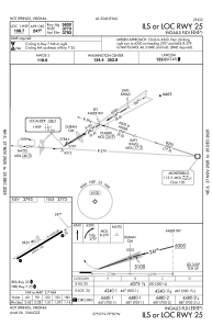
IAC chart of KHSP
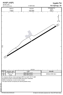
 ADC chart of KHSP
 Satellite view of KHSP
ADC chart of KHSP
Satellite view of KHSP
Sorry, we have no imagery here.
Sorry, we have no imagery here.
Sorry, we have no imagery here.
Sorry, we have no imagery here.
Sorry, we have no imagery here.
Sorry, we have no imagery here.


KHSP - Ingalls Fld
Located in Hot Springs, United States
ICAO - HSP, IATA - HSP
Data provided by AirmateGeneral information
Coordinates: N37°57'5" W79°50'2"
Elevation is 3792 feet MSL.
Magnetic variation is -08° East View others Airports in Virginia
Operational data
Special qualification required
Current time UTC:
Current local time:
Weather
METAR: KHSP 010935Z AUTO 29013G20KT 10SM OVC003 01/00 A2987 RMK AO2 T00090001
Communications frequencies: [VIEW]
Runways:
| RWY identifier | QFU | Length (ft) | Width (ft) | Surface | LDA (ft) |
| 07 | 59° | 5600 | 100 | ASPH | |
| 25 | 239° | 5600 | 100 | ASPH |
Airport contact information
Address: Hot Springs United States
Satellite view of KHSP
Sorry, we have no imagery here.
Sorry, we have no imagery here.
Sorry, we have no imagery here.
Sorry, we have no imagery here.
Sorry, we have no imagery here.
Sorry, we have no imagery here.