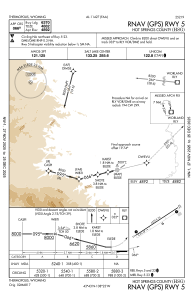
IAC chart of KHSG
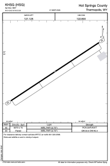
 ADC chart of KHSG
 Satellite view of KHSG
ADC chart of KHSG
Satellite view of KHSG
Sorry, we have no imagery here.
Sorry, we have no imagery here.
Sorry, we have no imagery here.
Sorry, we have no imagery here.
Sorry, we have no imagery here.
Sorry, we have no imagery here.


KHSG - Hot Springs County
Located in Thermopolis, United States
ICAO - HSG, IATA -
Data provided by AirmateGeneral information
Coordinates: N43°42'49" W108°23'23"
Elevation is 4891 feet MSL.
Magnetic variation is 10° East View others Airports in Wyoming
Operational data
Special qualification required
Current time UTC:
Current local time:
Weather
METAR: KHSG 080515Z AUTO 24009KT 10SM CLR 08/M02 A2989 RMK AO2 T00761021
Communications frequencies: [VIEW]
Runways:
| RWY identifier | QFU | Length (ft) | Width (ft) | Surface | LDA (ft) |
| 05 | 57° | 6370 | 75 | ASPH | |
| 23 | 237° | 6370 | 75 | ASPH |
Airport contact information
Address: Thermopolis United States
Satellite view of KHSG
Sorry, we have no imagery here.
Sorry, we have no imagery here.
Sorry, we have no imagery here.
Sorry, we have no imagery here.
Sorry, we have no imagery here.
Sorry, we have no imagery here.