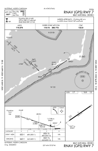
IAC chart of KHSE
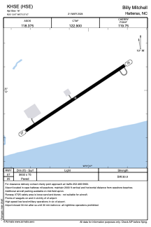
 ADC chart of KHSE
 Satellite view of KHSE
ADC chart of KHSE
Satellite view of KHSE
Sorry, we have no imagery here.
Sorry, we have no imagery here.
Sorry, we have no imagery here.
Sorry, we have no imagery here.
Sorry, we have no imagery here.
Sorry, we have no imagery here.


KHSE - Billy Mitchell
Located in Hatteras, United States
ICAO - HSE, IATA - HNC
Data provided by AirmateGeneral information
Coordinates: N35°13'58" W75°37'4"
Elevation is 16 feet MSL.
Magnetic variation is -10° East View others Airports in North Carolina
Operational data
Special qualification required
Current time UTC:
Current local time:
Weather
METAR: KHSE 021151Z AUTO 06004KT CLR 16/09 A3032 RMK AO2 SLP268 T01560094 10156 20122 53018 $
Communications frequencies: [VIEW]
Runways:
| RWY identifier | QFU | Length (ft) | Width (ft) | Surface | LDA (ft) |
| 07 | 57° | 3002 | 75 | ASPH | |
| 25 | 237° | 3002 | 75 | ASPH |
Airport contact information
Address: Hatteras United States
Satellite view of KHSE
Sorry, we have no imagery here.
Sorry, we have no imagery here.
Sorry, we have no imagery here.
Sorry, we have no imagery here.
Sorry, we have no imagery here.
Sorry, we have no imagery here.