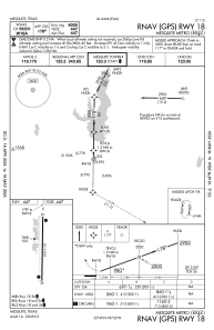
IAC chart of KHQZ
 ADC chart of KHQZ
 Satellite view of KHQZ
ADC chart of KHQZ
Satellite view of KHQZ
Sorry, we have no imagery here.
Sorry, we have no imagery here.
Sorry, we have no imagery here.
Sorry, we have no imagery here.
Sorry, we have no imagery here.
Sorry, we have no imagery here.


KHQZ - Mesquite Metro
Located in Mesquite, United States
ICAO - HQZ, IATA -
Data provided by AirmateGeneral information
Coordinates: N32°44'49" W96°31'50"
Elevation is 446 feet MSL.
Magnetic variation is 03° East View others Airports in Texas
Operational data
Special qualification required
Current time UTC:
Current local time:
Weather
METAR: KHQZ 021250Z 17019G29KT 3SM HZ BKN028 OVC035 23/18 A2953
Communications frequencies: [VIEW]
Runways:
| RWY identifier | QFU | Length (ft) | Width (ft) | Surface | LDA (ft) |
| 18 | 181° | 6000 | 100 | CONC | |
| 36 | 1° | 6000 | 100 | CONC |
Airport contact information
Address: Mesquite United States
Other aviation service providers
Flight schools

Satellite view of KHQZ
Sorry, we have no imagery here.
Sorry, we have no imagery here.
Sorry, we have no imagery here.
Sorry, we have no imagery here.
Sorry, we have no imagery here.
Sorry, we have no imagery here.