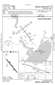
IAC chart of KHPY
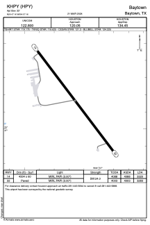
 ADC chart of KHPY
 Satellite view of KHPY
ADC chart of KHPY
Satellite view of KHPY
Sorry, we have no imagery here.
Sorry, we have no imagery here.
Sorry, we have no imagery here.
Sorry, we have no imagery here.
Sorry, we have no imagery here.
Sorry, we have no imagery here.


KHPY - Baytown
Located in Baytown, United States
ICAO - HPY, IATA - HPY
Data provided by AirmateGeneral information
Coordinates: N29°47'10" W94°57'10"
Elevation is 33 feet MSL.
Magnetic variation is 03° East View others Airports in Texas
Operational data
Special qualification required
Current time UTC:
Current local time:
Communications frequencies: [VIEW]
Runways:
| RWY identifier | QFU | Length (ft) | Width (ft) | Surface | LDA (ft) |
| 14 | 143° | 4334 | 60 | ASPH | 3320 |
| 32 | 323° | 4334 | 60 | ASPH | 3283 |
Airport contact information
Address: Baytown United States
Other aviation service providers
Flight schools

Satellite view of KHPY
Sorry, we have no imagery here.
Sorry, we have no imagery here.
Sorry, we have no imagery here.
Sorry, we have no imagery here.
Sorry, we have no imagery here.
Sorry, we have no imagery here.