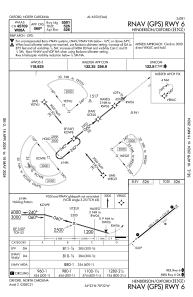
IAC chart of KHNZ
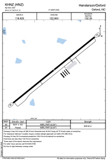
 ADC chart of KHNZ
 Satellite view of KHNZ
ADC chart of KHNZ
Satellite view of KHNZ
Sorry, we have no imagery here.
Sorry, we have no imagery here.
Sorry, we have no imagery here.
Sorry, we have no imagery here.
Sorry, we have no imagery here.
Sorry, we have no imagery here.


KHNZ - Henderson/Oxford
Located in Oxford, United States
ICAO - HNZ, IATA -
Data provided by AirmateGeneral information
Coordinates: N36°21'40" W78°31'47"
Elevation is 526 feet MSL.
Magnetic variation is -09° East View others Airports in North Carolina
Operational data
Special qualification required
Current time UTC:
Current local time:
Weather
METAR: KHNZ 021340Z AUTO 08004KT 10SM BKN025 BKN037 BKN047 10/05 A3033 RMK AO2 T01010049
Communications frequencies: [VIEW]
Runways:
| RWY identifier | QFU | Length (ft) | Width (ft) | Surface | LDA (ft) |
| 06 | 51° | 5501 | 100 | ASPH | |
| 24 | 231° | 5501 | 100 | ASPH |
Airport contact information
Address: Oxford United States
Other aviation service providers
Flight schools

Empire Aviation Flight School
Empire Aviation Flight School
learntofly@empire-aviation.com+1(919)693-4300
Satellite view of KHNZ
Sorry, we have no imagery here.
Sorry, we have no imagery here.
Sorry, we have no imagery here.
Sorry, we have no imagery here.
Sorry, we have no imagery here.
Sorry, we have no imagery here.