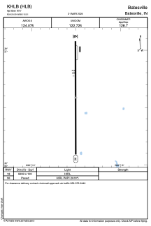
ADC chart of KHLB
 Satellite view of KHLB
Satellite view of KHLB
Sorry, we have no imagery here.
Sorry, we have no imagery here.
Sorry, we have no imagery here.
Sorry, we have no imagery here.
Sorry, we have no imagery here.
Sorry, we have no imagery here.


KHLB - Batesville
Located in Batesville, United States
ICAO - HLB, IATA - HLB
Data provided by AirmateGeneral information
Coordinates: N39°20'35" W85°15'30"
Elevation is 975 feet MSL.
Magnetic variation is -05° East View others Airports in Indiana
Operational data
Special qualification required
Current time UTC:
Current local time:
Weather
METAR: KHLB 050815Z AUTO 12005KT 6SM BR SCT002 BKN039 OVC120 12/12 A2999 RMK A01
Communications frequencies: [VIEW]
Runways:
| RWY identifier | QFU | Length (ft) | Width (ft) | Surface | LDA (ft) |
| 18 | 0° | 5933 | 100 | ASPH | |
| 36 | 0° | 5933 | 100 | ASPH |
Airport contact information
Address: Batesville United States
Satellite view of KHLB
Sorry, we have no imagery here.
Sorry, we have no imagery here.
Sorry, we have no imagery here.
Sorry, we have no imagery here.
Sorry, we have no imagery here.
Sorry, we have no imagery here.