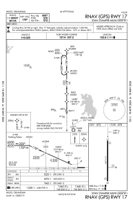
IAC chart of KHHW
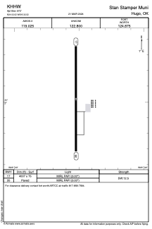
 ADC chart of KHHW
 Satellite view of KHHW
ADC chart of KHHW
Satellite view of KHHW
Sorry, we have no imagery here.
Sorry, we have no imagery here.
Sorry, we have no imagery here.
Sorry, we have no imagery here.
Sorry, we have no imagery here.
Sorry, we have no imagery here.


KHHW - Stan Stamper Muni
Located in Hugo, United States
ICAO - HHW, IATA - HUJ
Data provided by AirmateGeneral information
Coordinates: N34°2'1" W95°32'31"
Elevation is 572 feet MSL.
Magnetic variation is 02° East View others Airports in Oklahoma
Operational data
Special qualification required
Current time UTC:
Current local time:
Weather
METAR: KHHW 050755Z AUTO 02007KT 10SM OVC008 12/11 A2982 RMK AO2 LTG DSNT NE THRU SE
Communications frequencies: [VIEW]
Runways:
| RWY identifier | QFU | Length (ft) | Width (ft) | Surface | LDA (ft) |
| 17 | 180° | 4007 | 75 | ASPH | |
| 35 | 0° | 4007 | 75 | ASPH |
Airport contact information
Address: Hugo United States
Satellite view of KHHW
Sorry, we have no imagery here.
Sorry, we have no imagery here.
Sorry, we have no imagery here.
Sorry, we have no imagery here.
Sorry, we have no imagery here.
Sorry, we have no imagery here.