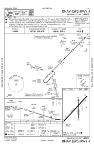
IAC chart of KHHF
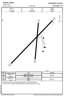
 ADC chart of KHHF
 Satellite view of KHHF
ADC chart of KHHF
Satellite view of KHHF
Sorry, we have no imagery here.
Sorry, we have no imagery here.
Sorry, we have no imagery here.
Sorry, we have no imagery here.
Sorry, we have no imagery here.
Sorry, we have no imagery here.


KHHF - Hemphill County
Located in Canadian, United States
ICAO - HHF, IATA -
Data provided by AirmateGeneral information
Coordinates: N35°53'42" W100°24'14"
Elevation is 2396 feet MSL.
Magnetic variation is 06° East View others Airports in Texas
Operational data
Special qualification required
Current time UTC:
Current local time:
Weather
METAR: KHHF 021235Z AUTO 28018G27KT 10SM CLR 11/M09 A2952 RMK AO2 T01141086
Communications frequencies: [VIEW]
Runways:
| RWY identifier | QFU | Length (ft) | Width (ft) | Surface | LDA (ft) |
| 04 | 44° | 5004 | 75 | ASPH | |
| 22 | 224° | 5004 | 75 | ASPH | |
| 18 | 185° | 3001 | 60 | ASPH | |
| 36 | 5° | 3001 | 60 | ASPH |
Airport contact information
Address: Canadian United States
Other aviation service providers
Flight schools

Satellite view of KHHF
Sorry, we have no imagery here.
Sorry, we have no imagery here.
Sorry, we have no imagery here.
Sorry, we have no imagery here.
Sorry, we have no imagery here.
Sorry, we have no imagery here.