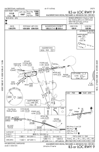
IAC chart of KHGR
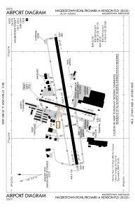
 ADC chart of KHGR
 Satellite view of KHGR
ADC chart of KHGR
Satellite view of KHGR
Sorry, we have no imagery here.
Sorry, we have no imagery here.
Sorry, we have no imagery here.
Sorry, we have no imagery here.
Sorry, we have no imagery here.
Sorry, we have no imagery here.


KHGR - Hagerstown Rgnl/Richard A Henson Fld
Located in Hagerstown, United States
ICAO - HGR, IATA - HGR
Data provided by AirmateGeneral information
Coordinates: N39°42'31" W77°43'35"
Elevation is 703 feet MSL.
Magnetic variation is -11° East View others Airports in Maryland
Operational data
Special qualification required
Current time UTC:
Current local time:
Weather
METAR: KHGR 051053Z 14006KT 10SM OVC030 16/08 A3016 RMK AO2 SLP222 T01610083 $
Communications frequencies: [VIEW]
Runways:
| RWY identifier | QFU | Length (ft) | Width (ft) | Surface | LDA (ft) |
| 02 | 15° | 3165 | 100 | ASPH | 3165 |
| 20 | 195° | 3165 | 100 | ASPH | 3165 |
| 09 | 81° | 7000 | 150 | ASPH | 7000 |
| 27 | 261° | 7000 | 150 | ASPH | 7000 |
Airport contact information
Address: Hagerstown United States
Other aviation service providers
Repair station

Flight schools

Satellite view of KHGR
Sorry, we have no imagery here.
Sorry, we have no imagery here.
Sorry, we have no imagery here.
Sorry, we have no imagery here.
Sorry, we have no imagery here.
Sorry, we have no imagery here.