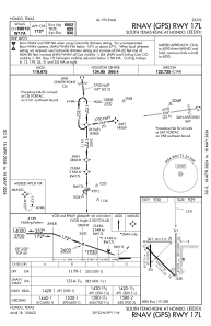
IAC chart of KHDO
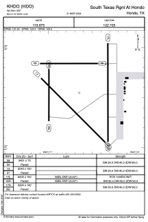
 ADC chart of KHDO
 Satellite view of KHDO
ADC chart of KHDO
Satellite view of KHDO
Sorry, we have no imagery here.
Sorry, we have no imagery here.
Sorry, we have no imagery here.
Sorry, we have no imagery here.
Sorry, we have no imagery here.
Sorry, we have no imagery here.


KHDO - South Texas Rgnl At Hondo
Located in Hondo, United States
ICAO - HDO, IATA -
Data provided by AirmateGeneral information
Coordinates: N29°21'33" W99°10'39"
Elevation is 930 feet MSL.
Magnetic variation is 08° East View others Airports in Texas
Operational data
Special qualification required
Current time UTC:
Current local time:
Weather
METAR: KHDO 021251Z AUTO 14007KT 9SM OVC014 23/21 A2955 RMK AO2 SLP988 T02330206
Communications frequencies: [VIEW]
Runways:
| RWY identifier | QFU | Length (ft) | Width (ft) | Surface | LDA (ft) |
| 08 | 90° | 3451 | 75 | CONC | |
| 26 | 270° | 3451 | 75 | CONC | |
| 13 | 135° | 5545 | 150 | CONC | |
| 31 | 315° | 5545 | 150 | CONC | |
| 17L | 180° | 6002 | 100 | CONC | |
| 35R | 360° | 6002 | 100 | CONC | |
| 17R | 180° | 3224 | 140 | ASPH | |
| 35L | 360° | 3224 | 140 | ASPH |
Airport contact information
Address: Hondo United States
Other aviation service providers
Flight schools

Satellite view of KHDO
Sorry, we have no imagery here.
Sorry, we have no imagery here.
Sorry, we have no imagery here.
Sorry, we have no imagery here.
Sorry, we have no imagery here.
Sorry, we have no imagery here.