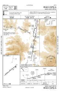
IAC chart of KHCR
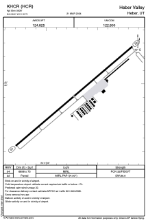
 ADC chart of KHCR
 Satellite view of KHCR
ADC chart of KHCR
Satellite view of KHCR
Sorry, we have no imagery here.
Sorry, we have no imagery here.
Sorry, we have no imagery here.
Sorry, we have no imagery here.
Sorry, we have no imagery here.
Sorry, we have no imagery here.


KHCR - Heber Valley
Located in Heber, United States
ICAO - HCR, IATA -
Data provided by AirmateGeneral information
Coordinates: N40°28'55" W111°25'44"
Elevation is 5636 feet MSL.
Magnetic variation is 11° East View others Airports in Utah
Operational data
Special qualification required
Current time UTC:
Current local time:
Weather at : KPVU - Provo Muni ( 38 km )
METAR: KPVU 011456Z 05005KT 10SM BKN011 BKN040 OVC048 01/00 A2968 RMK AO2 WSHFT 1351 RAE30SNB04E18 SLP053 P0001 60003 T00110000 53008
TAF: KPVU 011306Z 0113/0212 24015G25KT P6SM SCT015 BKN035 FM011600 30014G22KT P6SM VCSH SCT050 BKN070 PROB30 0121/0124 4SM -SHSN BKN030 FM020100 VRB05KT P6SM SCT070
Communications frequencies: [VIEW]
Runways:
| RWY identifier | QFU | Length (ft) | Width (ft) | Surface | LDA (ft) |
| 04 | 50° | 6898 | 75 | ASPH | |
| 22 | 230° | 6898 | 75 | ASPH |
Airport contact information
Address: Heber United States
Satellite view of KHCR
Sorry, we have no imagery here.
Sorry, we have no imagery here.
Sorry, we have no imagery here.
Sorry, we have no imagery here.
Sorry, we have no imagery here.
Sorry, we have no imagery here.