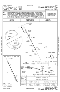
IAC chart of KGZS
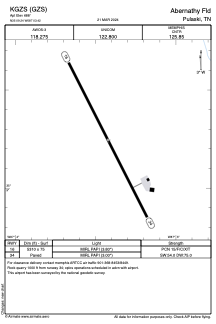
 ADC chart of KGZS
 Satellite view of KGZS
ADC chart of KGZS
Satellite view of KGZS
Sorry, we have no imagery here.
Sorry, we have no imagery here.
Sorry, we have no imagery here.
Sorry, we have no imagery here.
Sorry, we have no imagery here.
Sorry, we have no imagery here.


KGZS - Abernathy Fld
Located in Pulaski, United States
ICAO - GZS, IATA -
Data provided by AirmateGeneral information
Coordinates: N35°9'15" W87°3'25"
Elevation is 688 feet MSL.
Magnetic variation is -02° East View others Airports in Tennessee
Operational data
Special qualification required
Current time UTC:
Current local time:
Weather
METAR: KGZS 081215Z AUTO VRB05KT 10SM CLR 05/03 A3005 RMK A01
Communications frequencies: [VIEW]
Runways:
| RWY identifier | QFU | Length (ft) | Width (ft) | Surface | LDA (ft) |
| 16 | 153° | 5310 | 75 | ASPH | |
| 34 | 333° | 5310 | 75 | ASPH |
Airport contact information
Address: Pulaski United States
Satellite view of KGZS
Sorry, we have no imagery here.
Sorry, we have no imagery here.
Sorry, we have no imagery here.
Sorry, we have no imagery here.
Sorry, we have no imagery here.
Sorry, we have no imagery here.