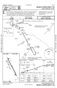
IAC chart of KGUR
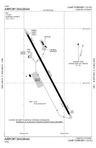
 ADC chart of KGUR
 Satellite view of KGUR
ADC chart of KGUR
Satellite view of KGUR
Sorry, we have no imagery here.
Sorry, we have no imagery here.
Sorry, we have no imagery here.
Sorry, we have no imagery here.
Sorry, we have no imagery here.
Sorry, we have no imagery here.


KGUR - Camp Guernsey
Located in Guernsey, United States
ICAO - GUR, IATA -
Data provided by AirmateGeneral information
Coordinates: N42°15'35" W104°43'42"
Elevation is 4401 feet MSL.
Magnetic variation is 11° East View others Airports in Wyoming
Operational data
Special qualification required
Current time UTC:
Current local time:
Weather
METAR: KGUR 081855Z AUTO 27018G25KT 9SM BKN200 BKN270 23/M04 A2980 RMK AO2 PK WND 29026/12 SLP085 T02261045
TAF: TAF KGUR 081300Z 0813/0919 27010KT 9999 FEW120 QNH2987INS BECMG 0815/0816 28015G35KT 9999 FEW110 FEW160 SCT220 QNH2986INS BECMG 0902/0903 31012G20KT 9999 FEW140 QNH2998INS BECMG 0906/0908 31009KT 9999 FEW140 520009 520901 QNH3001INS BECMG 0915/0917 29015G28KT 9999 SKC QNH3008INS TX21/0820Z TN00/0911Z
Communications frequencies: [VIEW]
Runways:
| RWY identifier | QFU | Length (ft) | Width (ft) | Surface | LDA (ft) |
| 14 | 152° | 5060 | 90 | ASPH | |
| 32 | 332° | 5060 | 90 | ASPH | |
| H1 | 0° | 0 | 0 | UNK | |
| H2 | 0° | 0 | 0 | UNK | |
| H3 | 0° | 0 | 0 | UNK |
Airport contact information
Address: Guernsey United States
Satellite view of KGUR
Sorry, we have no imagery here.
Sorry, we have no imagery here.
Sorry, we have no imagery here.
Sorry, we have no imagery here.
Sorry, we have no imagery here.
Sorry, we have no imagery here.