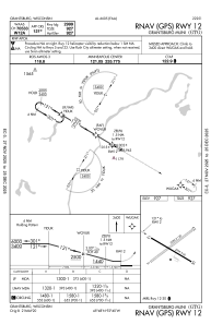
IAC chart of KGTG
 Satellite view of KGTG
Satellite view of KGTG
Sorry, we have no imagery here.
Sorry, we have no imagery here.
Sorry, we have no imagery here.
Sorry, we have no imagery here.
Sorry, we have no imagery here.
Sorry, we have no imagery here.


KGTG - Grantsburg Muni
Located in Grantsburg, United States
ICAO - GTG, IATA - GTG
Data provided by AirmateGeneral information
Coordinates: N45°47'54" W92°39'52"
Elevation is 927 feet MSL.
Magnetic variation is 00° East View others Airports in Wisconsin
Operational data
Special qualification required
Current time UTC:
Current local time:
Weather at : KRZN - Burnett County ( 23 km )
METAR: KRZN 301535Z AUTO 29007KT 10SM CLR 19/09 A2989 RMK AO2 T01850093
Communications frequencies: [VIEW]
Runways:
| RWY identifier | QFU | Length (ft) | Width (ft) | Surface | LDA (ft) |
| 05 | 56° | 3280 | 120 | GRASS | |
| 23 | 236° | 3280 | 120 | GRASS | |
| 12 | 121° | 2999 | 60 | ASPH | |
| 30 | 301° | 2999 | 60 | ASPH |
Airport contact information
Address: Grantsburg United States
Satellite view of KGTG
Sorry, we have no imagery here.
Sorry, we have no imagery here.
Sorry, we have no imagery here.
Sorry, we have no imagery here.
Sorry, we have no imagery here.
Sorry, we have no imagery here.