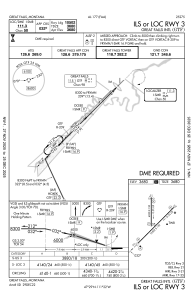
IAC chart of KGTF
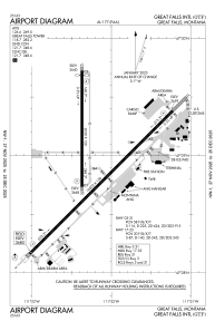
 ADC chart of KGTF
 Satellite view of KGTF
ADC chart of KGTF
Satellite view of KGTF
Sorry, we have no imagery here.
Sorry, we have no imagery here.
Sorry, we have no imagery here.
Sorry, we have no imagery here.
Sorry, we have no imagery here.
Sorry, we have no imagery here.


KGTF - Great Falls Intl
Located in Great Falls, United States
ICAO - GTF, IATA - GTF
Data provided by AirmateGeneral information
Coordinates: N47°28'56" W111°22'13"
Elevation is 3680 feet MSL.
Magnetic variation is 13° East View others Airports in Montana
Operational data
Special qualification required
Current time UTC:
Current local time:
Weather
METAR: KGTF 051153Z 20010KT 10SM CLR M04/M08 A3033 RMK AO2 SLP308 T10441083 11033 21061 56004
TAF: KGTF 051120Z 0512/0612 21009KT P6SM FEW200 FM051600 23013G20KT P6SM SKC FM060100 22008KT P6SM SKC
Communications frequencies: [VIEW]
Runways:
| RWY identifier | QFU | Length (ft) | Width (ft) | Surface | LDA (ft) |
| 03 | 45° | 10502 | 150 | ASPH | 10502 |
| 21 | 225° | 10502 | 150 | ASPH | 10502 |
| 17 | 180° | 6030 | 150 | ASPH | 5800 |
| 35 | 360° | 6030 | 150 | ASPH | 5400 |
Airport contact information
Address: Great Falls United States
Satellite view of KGTF
Sorry, we have no imagery here.
Sorry, we have no imagery here.
Sorry, we have no imagery here.
Sorry, we have no imagery here.
Sorry, we have no imagery here.
Sorry, we have no imagery here.