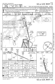
IAC chart of KGRF
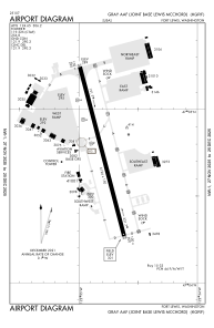
 ADC chart of KGRF
 Satellite view of KGRF
ADC chart of KGRF
Satellite view of KGRF
Sorry, we have no imagery here.
Sorry, we have no imagery here.
Sorry, we have no imagery here.
Sorry, we have no imagery here.
Sorry, we have no imagery here.
Sorry, we have no imagery here.


KGRF - Gray Aaf (Joint Base Lewis-Mcchord)
Located in Fort Lewis/Tacoma, United States
ICAO - GRF, IATA - GRF
Data provided by AirmateGeneral information
Coordinates: N47°4'45" W122°34'51"
Elevation is 301 feet MSL.
Magnetic variation is 16° East View others Airports in Washington
Operational data
Special qualification required
Current time UTC:
Current local time:
Weather
METAR: KGRF 051055Z AUTO 00000KT 10SM SCT200 03/01 A3026 RMK AO2 SLP251 T00340013 $
TAF: TAF KGRF 050500Z 0505/0611 25006KT 9999 SCT250 QNH3023INS BECMG 0521/0522 35005KT 9999 -RA SCT120 BKN140 OVC160 QNH3018INS BECMG 0603/0604 16003KT 9999 NSW FEW070 SCT090 BKN120 QNH3012INS TX15/0522Z TN03/0514Z
Communications frequencies: [VIEW]
Runways:
| RWY identifier | QFU | Length (ft) | Width (ft) | Surface | LDA (ft) |
| 15 | 167° | 6124 | 150 | ASPH | |
| 33 | 347° | 6124 | 150 | ASPH | |
| H2 | 0° | 0 | 0 | UNK | |
| H3 | 0° | 0 | 0 | UNK | |
| H4 | 0° | 0 | 0 | UNK |
Airport contact information
Address: Fort Lewis/Tacoma United States
Satellite view of KGRF
Sorry, we have no imagery here.
Sorry, we have no imagery here.
Sorry, we have no imagery here.
Sorry, we have no imagery here.
Sorry, we have no imagery here.
Sorry, we have no imagery here.