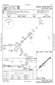
IAC chart of KGQQ
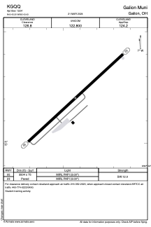
 ADC chart of KGQQ
 Satellite view of KGQQ
ADC chart of KGQQ
Satellite view of KGQQ
Sorry, we have no imagery here.
Sorry, we have no imagery here.
Sorry, we have no imagery here.
Sorry, we have no imagery here.
Sorry, we have no imagery here.
Sorry, we have no imagery here.


KGQQ - Galion Muni
Located in Galion, United States
ICAO - GQQ, IATA - GQQ
Data provided by AirmateGeneral information
Coordinates: N40°45'12" W82°43'26"
Elevation is 1224 feet MSL.
Magnetic variation is -07° East View others Airports in Ohio
Operational data
Special qualification required
Current time UTC:
Current local time:
Weather at : KMFD - Mansfield Lahm Rgnl ( 19 km )
METAR: KMFD 081552Z 33012G17KT 10SM BKN030 M02/M09 A3010 RMK AO2 SLP207 T10221094 $
TAF: KMFD 081131Z 0812/0912 31014G21KT P6SM OVC035 FM081700 31011KT P6SM FEW070 FM082300 30008KT P6SM SCT070 FM090400 29005KT P6SM FEW250
Communications frequencies: [VIEW]
Runways:
| RWY identifier | QFU | Length (ft) | Width (ft) | Surface | LDA (ft) |
| 05 | 47° | 3504 | 75 | ASPH | |
| 23 | 227° | 3504 | 75 | ASPH |
Airport contact information
Address: Galion United States
Other aviation service providers
Flight schools

Satellite view of KGQQ
Sorry, we have no imagery here.
Sorry, we have no imagery here.
Sorry, we have no imagery here.
Sorry, we have no imagery here.
Sorry, we have no imagery here.
Sorry, we have no imagery here.