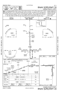
IAC chart of KGNC
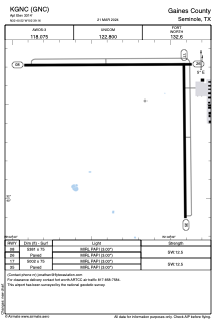
 ADC chart of KGNC
 Satellite view of KGNC
ADC chart of KGNC
Satellite view of KGNC
Sorry, we have no imagery here.
Sorry, we have no imagery here.
Sorry, we have no imagery here.
Sorry, we have no imagery here.
Sorry, we have no imagery here.
Sorry, we have no imagery here.


KGNC - Gaines County
Located in Seminole, United States
ICAO - GNC, IATA -
Data provided by AirmateGeneral information
Coordinates: N32°40'31" W102°39'10"
Elevation is 3314 feet MSL.
Magnetic variation is 09° East View others Airports in Texas
Operational data
Special qualification required
Current time UTC:
Current local time:
Weather
METAR: KGNC 021355Z AUTO 32008KT 10SM CLR 10/M06 A2974 RMK AO2 T01001059
Communications frequencies: [VIEW]
Runways:
| RWY identifier | QFU | Length (ft) | Width (ft) | Surface | LDA (ft) |
| 08 | 90° | 5381 | 75 | ASPH | |
| 26 | 270° | 5381 | 75 | ASPH | |
| 17 | 179° | 5002 | 75 | ASPH | |
| 35 | 359° | 5002 | 75 | ASPH |
Airport contact information
Address: Seminole United States
Satellite view of KGNC
Sorry, we have no imagery here.
Sorry, we have no imagery here.
Sorry, we have no imagery here.
Sorry, we have no imagery here.
Sorry, we have no imagery here.
Sorry, we have no imagery here.