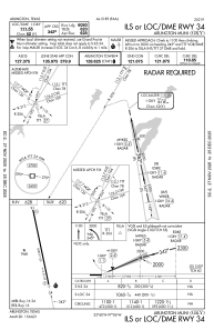
IAC chart of KGKY
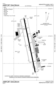
 ADC chart of KGKY
 Satellite view of KGKY
ADC chart of KGKY
Satellite view of KGKY
Sorry, we have no imagery here.
Sorry, we have no imagery here.
Sorry, we have no imagery here.
Sorry, we have no imagery here.
Sorry, we have no imagery here.
Sorry, we have no imagery here.


KGKY - Arlington Muni
Located in Arlington, United States
ICAO - GKY, IATA -
Data provided by AirmateGeneral information
Coordinates: N32°39'50" W97°5'39"
Elevation is 628 feet MSL.
Magnetic variation is 06° East View others Airports in Texas
Operational data
Special qualification required
Current time UTC:
Current local time:
Weather
METAR: KGKY 021323Z 16011KT 1 3/4SM RA OVC019 23/20 A2954 RMK AO2 RAB15 P0001 T02280200
TAF: KGKY 021238Z 0213/0312 18018G28KT P6SM BKN020 FM021400 22015KT P6SM VCTS BKN025CB TEMPO 0214/0216 28014KT 4SM TSRA FM021600 29012KT P6SM BKN090 FM021800 28010KT P6SM BKN250 FM030100 04006KT P6SM BKN250 FM030800 07006KT P6SM BKN015
Communications frequencies: [VIEW]
Runways:
| RWY identifier | QFU | Length (ft) | Width (ft) | Surface | LDA (ft) |
| 16 | 168° | 6080 | 100 | CONC | |
| 34 | 348° | 6080 | 100 | CONC |
Airport contact information
Address: Arlington United States
Other aviation service providers
Flight schools

Satellite view of KGKY
Sorry, we have no imagery here.
Sorry, we have no imagery here.
Sorry, we have no imagery here.
Sorry, we have no imagery here.
Sorry, we have no imagery here.
Sorry, we have no imagery here.