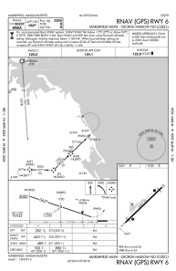
IAC chart of KGHG
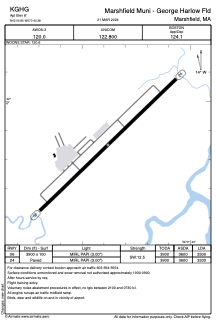
 ADC chart of KGHG
 Satellite view of KGHG
ADC chart of KGHG
Satellite view of KGHG
Sorry, we have no imagery here.
Sorry, we have no imagery here.
Sorry, we have no imagery here.
Sorry, we have no imagery here.
Sorry, we have no imagery here.
Sorry, we have no imagery here.


KGHG - Marshfield Muni - George Harlow Fld
Located in Marshfield, United States
ICAO - GHG, IATA -
Data provided by AirmateGeneral information
Coordinates: N42°5'51" W70°40'23"
Elevation is 8 feet MSL.
Magnetic variation is -16° East View others Airports in Massachusetts
Operational data
Special qualification required
Current time UTC:
Current local time:
Weather
METAR: KGHG 011535Z AUTO 30012G20KT 250V320 10SM FEW095 10/M02 A2981 RMK AO2
Communications frequencies: [VIEW]
Runways:
| RWY identifier | QFU | Length (ft) | Width (ft) | Surface | LDA (ft) |
| 06 | 46° | 3900 | 100 | ASPH | 3300 |
| 24 | 226° | 3900 | 100 | ASPH | 3300 |
Airport contact information
Address: Marshfield United States
Other aviation service providers
Flight schools

Satellite view of KGHG
Sorry, we have no imagery here.
Sorry, we have no imagery here.
Sorry, we have no imagery here.
Sorry, we have no imagery here.
Sorry, we have no imagery here.
Sorry, we have no imagery here.