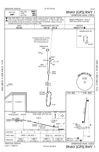
IAC chart of KGEZ
 Satellite view of KGEZ
Satellite view of KGEZ
Sorry, we have no imagery here.
Sorry, we have no imagery here.
Sorry, we have no imagery here.
Sorry, we have no imagery here.
Sorry, we have no imagery here.
Sorry, we have no imagery here.


KGEZ - Shelbyville Muni
Located in Shelbyville, United States
ICAO - GEZ, IATA -
Data provided by AirmateGeneral information
Coordinates: N39°34'59" W85°48'17"
Elevation is 802 feet MSL.
Magnetic variation is -04° East View others Airports in Indiana
Operational data
Special qualification required
Current time UTC:
Current local time:
Weather
METAR: KGEZ 050953Z AUTO 17015G22KT 8SM RA OVC100 17/14 A2993 RMK AO2 SLP132 P0003 T01670144
Communications frequencies: [VIEW]
Runways:
| RWY identifier | QFU | Length (ft) | Width (ft) | Surface | LDA (ft) |
| 01 | 5° | 5000 | 100 | ASPH | |
| 19 | 185° | 5000 | 100 | ASPH | |
| 09 | 92° | 2671 | 190 | GRASS | |
| 27 | 272° | 2671 | 190 | GRASS |
Airport contact information
Address: Shelbyville United States
Satellite view of KGEZ
Sorry, we have no imagery here.
Sorry, we have no imagery here.
Sorry, we have no imagery here.
Sorry, we have no imagery here.
Sorry, we have no imagery here.
Sorry, we have no imagery here.