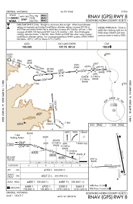
IAC chart of KGEY
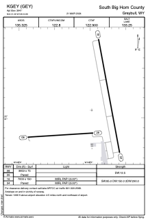
 ADC chart of KGEY
 Satellite view of KGEY
ADC chart of KGEY
Satellite view of KGEY
Sorry, we have no imagery here.
Sorry, we have no imagery here.
Sorry, we have no imagery here.
Sorry, we have no imagery here.
Sorry, we have no imagery here.


KGEY - South Big Horn County
Located in Greybull, United States
ICAO - GEY, IATA - GEY
Data provided by AirmateGeneral information
Coordinates: N44°31'5" W108°4'59"
Elevation is 3941 feet MSL.
Magnetic variation is 10° East View others Airports in Wyoming
Operational data
Special qualification required
Current time UTC:
Current local time:
Weather
METAR: KGEY 081453Z AUTO 12006KT 10SM FEW090 FEW110 12/M01 A2985 RMK AO2 SLP090 T01171011 53004
Communications frequencies: [VIEW]
Runways:
| RWY identifier | QFU | Length (ft) | Width (ft) | Surface | LDA (ft) |
| 08 | 86° | 3953 | 75 | ASPH | |
| 26 | 266° | 3953 | 75 | ASPH | |
| 16 | 169° | 7003 | 150 | ASPH | |
| 34 | 349° | 7003 | 150 | ASPH |
Airport contact information
Address: Greybull United States
Satellite view of KGEY
Sorry, we have no imagery here.
Sorry, we have no imagery here.
Sorry, we have no imagery here.
Sorry, we have no imagery here.
Sorry, we have no imagery here.