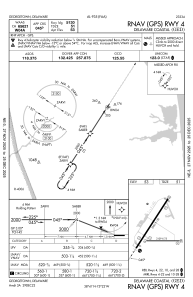
IAC chart of KGED
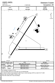
 ADC chart of KGED
 Satellite view of KGED
ADC chart of KGED
Satellite view of KGED
Sorry, we have no imagery here.
Sorry, we have no imagery here.
Sorry, we have no imagery here.
Sorry, we have no imagery here.
Sorry, we have no imagery here.
Sorry, we have no imagery here.


KGED - Delaware Coastal
Located in Georgetown, United States
ICAO - GED, IATA - GED
Data provided by AirmateGeneral information
Coordinates: N38°41'15" W75°21'33"
Elevation is 53 feet MSL.
Magnetic variation is -12° East View others Airports in Delaware
Operational data
Special qualification required
Current time UTC:
Current local time:
Weather
METAR: KGED 242054Z AUTO 30008G20KT 10SM SCT070 21/04 A3002 RMK AO2 SLP166 T02060044 58000
Communications frequencies: [VIEW]
Runways:
| RWY identifier | QFU | Length (ft) | Width (ft) | Surface | LDA (ft) |
| 04 | 33° | 5500 | 150 | ASPH | |
| 22 | 213° | 5500 | 150 | ASPH | |
| 10 | 90° | 3109 | 75 | ASPH | |
| 28 | 270° | 3109 | 75 | ASPH |
Airport contact information
Address: Georgetown United States
Other aviation service providers
Flight schools

Satellite view of KGED
Sorry, we have no imagery here.
Sorry, we have no imagery here.
Sorry, we have no imagery here.
Sorry, we have no imagery here.
Sorry, we have no imagery here.
Sorry, we have no imagery here.